

Types fast, thinks slow
why even fly? Just jump up high in San Francisco, and wait for the earth to revolve beneath you before coming back down and landing in Houston. Houston, no problem.
We don’t live in a Meritocracy, not even close.
True meritocracy had never been implemented in any human society larger than a small village.
It had been partially implemented in several places/times
What we have today is a partially implemented one in middle management, technocrats and engineers.
Where out of touch upper management and owners are the rule. But if I look at any successful company I will find the tech and middle management running it day to day
We’re so close to just having the workers run their own affairs, the table is set we just have to make everyone realize the actual owners are useless and do nothing
And more than just realizing that, we need to find a realistic path to take that power away from them.
And more than that not have a different group of upper class later. As had happened always.
I’d rather not go through the churn if no real difference a few years later
For those wondering why it did fly that way, it was a whole thing on Twitter: weather, fly zones, mostly.
https://www.thepoke.com/2025/02/26/elon-musk-said-planes-fly-straight-line-owned-into-economy-class/
Obviously the permanent main character on Twitter popped up to assert that planes must go straight despite flying in a private jet constantly that doesn’t do that, and after a few hours the original guy said he asked the pilot when they landed (20 min ahead of schedule) and the pilot told him it was to avoid turbulence, which is likely what they say when a full answer seems like it’ll just go over folks heads.
Elon Musk “rocket scientist”
There’s also the Great Circle flight paths. Essentially, because the earth is round, it’s actually a shorter distance to fly in an “arc” (when looking at a flat map). In the below picture, the upper curved line is actually shorter than the lower straight line:
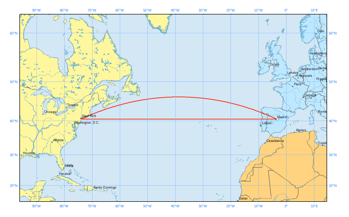
Here’s another image which demonstrates why the curved line looks longer on a flat map:
And because of how map projections work, this applies to virtually any flight path that isn’t directly north/south… Just like the one in OP’s photo.
The path in the post has nothing to do with the great circle. The shortest path is very similar to how it appears on the Mercator projection (actually slightly bent in the other direction) because SF and Houston are fairly close and in a position where Mercator distortions are less pronounced.

Also, a line is the shortest path when the 2 points are both on the Equator (where the projection distortion is zero)
Worth pointing out too, that the air isn’t “flat” either, you can have headwinds, tailwinds, and turbulence that will affect the shortest and most economical path.
It’s also good to mention that the projection shown in the tweet wasn’t Mercator either, it was a globe rendered via Apple Maps.
There’s also the fact that the earth is an oblate spheroid and great circles are the shortest distance between two points on that shape. (Though this may not apply for short flights like this.)
And it doesn’t apply because it would be curved upwards
Because the chemtrails turned the flight paths gay
no, this is SF to LA. It was the estrogen in the water that turned the flight path gay.
edit: we may also have local aviation laws that prevent straight flight paths. I’m not familiar with california aviation laws.
Musk’s DOGE let data leak, erased data from a goverment db by misstake, fired important figure working with nuke programs, Ebola and more in front of the whole fucking world.
Can you imagine a bigger fuck up?
For now I assume that the whole thing is working out well for Mr. Musk. By now he has probably weakened the specific agencies that were a thorn in his side sufficiently he’ll earn back the few hundred million it cost him to buy that position.
So he’s not an idiot, but he’s a problem.
Yes, the person who hired Musk
Ah, but he didn’t hire him, he just made him an advisor. Hiring him would required oversight that would have given others a chance to give a firm “Fuck No”.
And the 77 million people who voted for that person despite knowing exactly who he was.
Y’all, this has nothing to do with the curvature of the Earth. There are mountains and multiple no-fly zones that would be crossed if they flew in a straight line.
It’s still presented in an anti-intellectual “just asking questions” format though.
Further we are all just internet jabronis. It isn’t literally our job to know this stuff. Knowing this stuff is kind of literally this guys job. Knowing the things you just described is kind of the whole “logistics” thing.
Whatever the reasons for the path are, we accept that qualified people know what they are doing. In asking this question, he is showing how unqualified he is.
I worked for almost 40 years at a company that made rocket engines. For the first couple decades (and all the time prior to my starting there), the head of the company was someone who came up through the ranks. They were very knowledgeable about rocket engines, or at least very knowledgeable at the aspect that they worked on (there are a lot of specialties involved), and somewhat knowledgeable about the others.
But as the company traded hands, we ended up with CEOs or GMs that knew nothing about rockets and instead were just focused on the business aspects of it. Some of them were smart people, but they wouldn’t have cared if the company was making spoons or skateboards. From my vantage point, the company really went downhill when that happened, but I don’t think it’s uncommon these days.
So I wouldn’t be surprised if this guy knows nothing about logistics.
Thank you for articulating why exactly I felt this way about the post. I couldn’t quite get to that point myself.
Maybe I’m reading too much into this, but this kind of sounds like a technofascist trial balloon to push for the privatization of the US military. The implication being
Why can’t our nation’s air industry not simply buy the right to fly through no-fly zones? This is deep state oppression curtailing YOUR freedoms to go where-ever you please. If we just privatize military research and production it will be more productive (SpaceX is better than NASA) and American (a big state is communist; those military officers that don’t want to invade Canada are traitors), and people can fly over SpaceX’s latest acquisition Area 51X if they buy the rights.
Project 2025 was not written by Trump even if he is the executor/scapegoat. Smart people exist and work for the politicians, shareholders and lobbyists that shape current US policy. And trial balloons don’t need to be cleverly worked out, in the era of Trump you can just throw stuff at the wall, see what sticks, and pay private media to not make a story out of the rest. There’s a good chance this will come to nothing, but why wouldn’t a petty technocrat try to ingratiate himself to the new technofascist regime by offering a win-win.
They neither teach nor require smart at management schools.
I’m confused. People are saying this is due to earths curvature, but this is in the northern hemisphere so shorter paths should be more northern, not more southern.
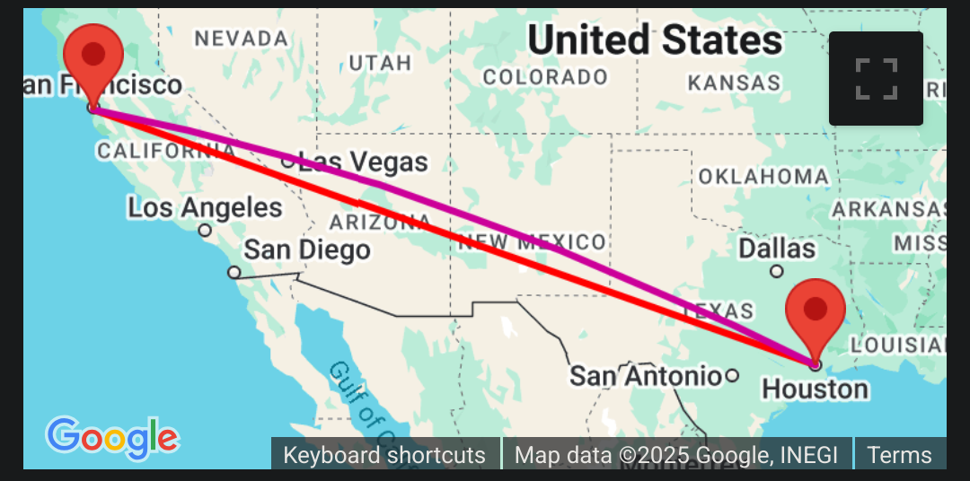
See this map of the actual shortest distance line (purple) for those two points. The image OP’s question seems much more reasonable given this information?
Planes don’t fly great circle routes though, there’s overfly fees, weather, mountains, ETOPS and just plain politics… This route looks ordinary compared to some international routes, eg Helsinki to Singapore where you dodge Russia and Ukraine for politics, taking you way below the great circle route, then Turkey for overfly fees and Iran for politics, taking you almost back up to the great circle route, before dipping down again to avoid the Himalayas
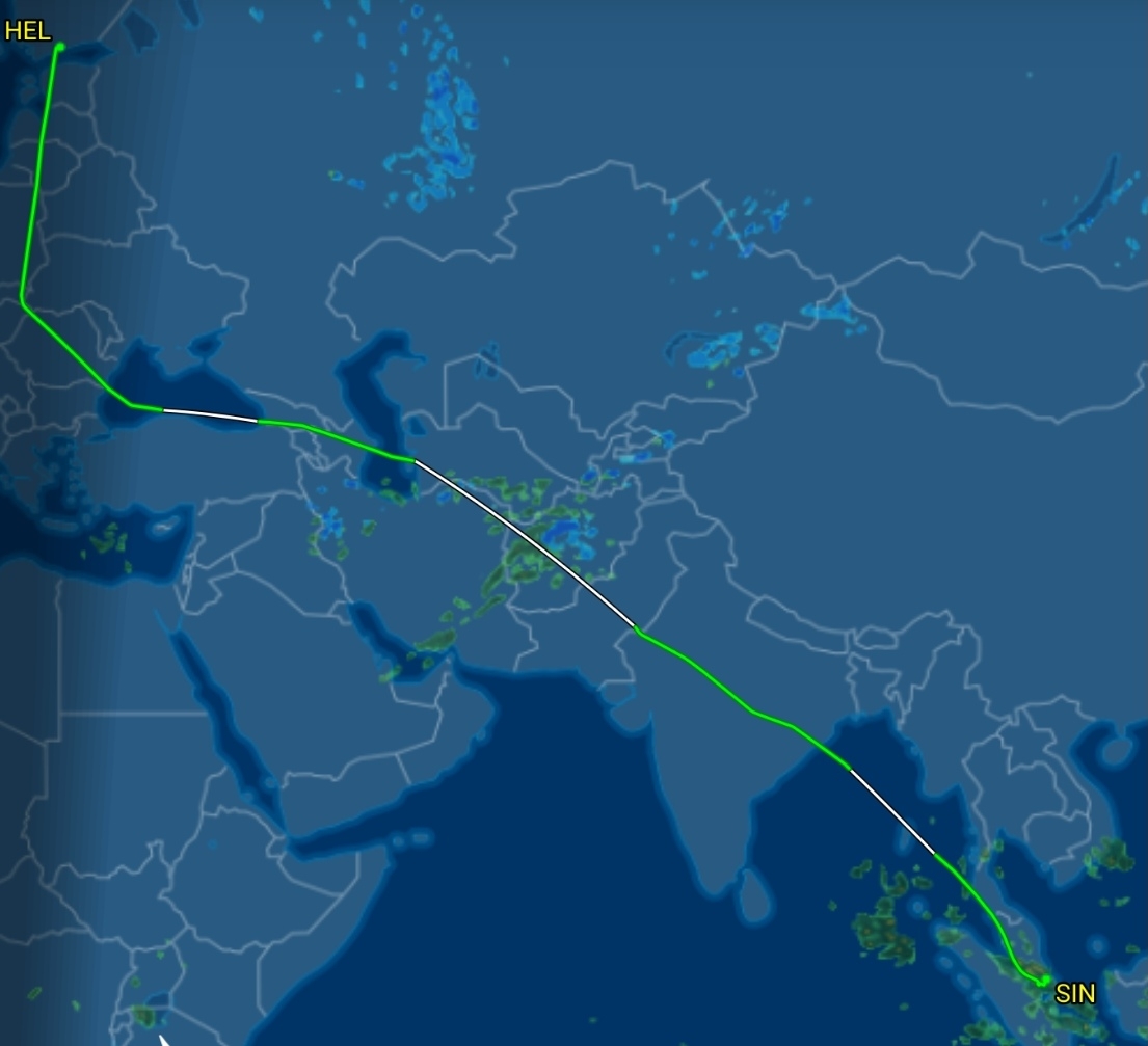
you dodge… Iran for politics
Except Northern Iran, from the looks of it
Green is actual data, white is straight lines connecting the green, but they don’t have data.
The cut across Northern Iran is just a straight line, but they will have stayed north of the border.
The question is very reasonable - and the answer far from obvious as evident from the wrong one being uprooted in this thread. To be clear: I don’t know the answer either, only that you’re right about the curve going the wrong way.
What’s more worrying is the CEO of a global logistics company asking it - and on a public forum rather than of his employees.
It’s akin to a school director standing in the schoolyard during recess and asking why his teachers aren’t in the classroom teaching at that moment.
He’s not asking because he understands great circles or is suddenly curious about planes. He’s “just asking questions”, specifically on a public forum to drum up disinformation and anti-science rhetoric. He’s essentially giving a shout-out to his conservative skeptic gang that if powerful rich people question science and common knowledge, they should keep doing it too
I think the more concerning thing is this question appears to be asked in a way that’s insulting to the pilot. What was the guy concerned about? Flight time? Fuel use? He could have made a polite question asking pilots on Twitter about what influences flight paths.
The pilot flying the plane obviously chose this path on purpose and this guy takes the very American position that admission of ignorance is a weakness.
The pilot flying the plane obviously chose this path on purpose
I think most corporate pilots have a company center that works out the flight paths for them. This probably doesn’t apply to private jets tho.
- The question is not stupid at all.
- we would expect the CEO of a logistics company to be able to answer such a question (or at least know who to ask to get the right answer), instead of asking it on X. Asking it on X at best shows of his ignorance, or at worst pushes a conspiracy theory.
It’s the way ATC routing works. In this case they might route SFO - IAH traffic over the southern route because it doesn’t interfere with westbound traffic heading to PHX or SFO, and this might be over southern airways. Go IAH - SFO and the route might be northern over LAS as route you plotted shows to mesh with the larger traffic flow going E to W. Who knows. But ATC routing often doesn’t follow a straight line, there’s lots of factors that send aircraft over less efficient routes.
It’s still not a great question in the context OP posted it because, as others have mentioned, the question is phrased as an accusation (JAQ-ing off) that makes no attempt to understand the airspace system and is probably asked in bad faith by Petersen.
My heard-from-online understanding is that this is a combination of multiple factors:
- planes tend to route over major airports so that there’s always an emergency landing site nearby
- there are restricted airspaces that commercial planes cannot fly through
- the most direct path sometimes isn’t the best path. There are stable wind channels in certain areas of the world and it’s more efficient to ride the wind channel than to fly in a straight line
- planes tend to route over major airports so that there’s always an emergency landing site nearby
I think you’ve got it right. This flight path is basically:
SFO > LAX > PHX > ELP > AUS > IAH
The post is indeed not a great circle.
Redraw the path nearest to the red line but avoid the areas marked in green and you have your answer. Arizona is at a pretty high elevation and the rockies stretch from new mexico through colorado onwards, so they probably fly around the other way under the Rockies.
Edit: i think his question is still disingenuous
He should ask Luigi for a detailed description of fly-zones, fuel consumption vs altitude and terrain, and air traffic (timing) to a lesser extent.
You are way overthinking it, the problem suggested by OP is much simpler: it‘s all about the mercator projection of the map.
I hate people who blame the Mercator projection without properly learning about what is wrong with it.
- This is not a Mercator projection map. The northern side of the US is straight and horizontal on Mercartor maps.
- “Straight lines” on a globe (great circles) on the Northern hemisphere bend in this ⏜ way, not this ⏝ on a Mercartor map.
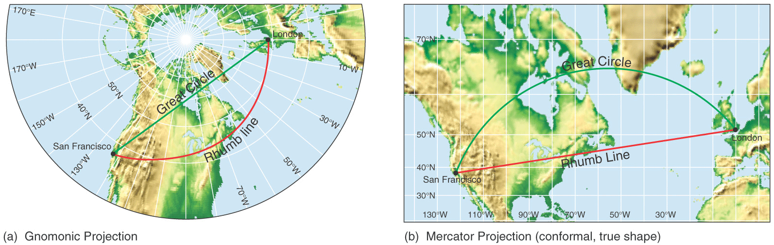
- Flattening a sphere without compromises is impossible. Most other projections are either unusable in many local contexts or don’t span the globe. Mercator (specifically the WGS-84 implementation) works very well unless your journey goes over ±84° latitude, which is OK for most cases. Every other projection will stretch, skew or cut local areas in major ways and EVERY ONE WILL SHOW (almost every instance of) THE SHORTEST (great circle) PATH AS NOT STRAIGHT. And the last, all-caps point only manifests for long journeys. If you can travel long distances in a straight line, you are piloting a ship or aircraft, and you can afford a computer to plot the great circle curve.
Actual problems with Mercator:
- It needs to be infinitely tall to cover poles. This map shows how tall a version that gets to .1 mm from the South Pole is. Therefore, polar researchers and the military need to get another app for navigation (along with hardware for whatever the substitute for GPS is).
- It significantly distorts sizes at different latitudes so it’s not recommended for showing the entire world, especially for a child’s first impression. There are worse picks, such as Gall-Peters (which preserves sizes but stretches shapes horribly unless you are close to the very conveniently picked 45° latitude where most of the Europe lives, nullifying the notion that the map combats imperiallism) or Dymaxion (which I love but cutting oceans and the equator into incongruent pieces strewn all over the page does not help children grasp basic geography).
I’m rather impressed by your two unicode curve examples
I’ve scrolled through UnicodePad so many times I know what to expect where, so I usually only have to skim through one to three block.
nope. This is the straight line path on a Mercator map

I know, but thats what OP from screenshots suggestion most likely was.
“Sadly” not really. As this is the northern hemisphere the “shorter” path would be an arc opening downwards. As others have commented, there are other reasons for this route.
If that is the case, then op is wrong, that’s not how mercator works (the opposite actually).
(I’m glad this isn’t Reddit or I would be forced by custom to explain in detail the sexy times I had with their mother.)But aviation logistic is complex (duh), there are so many things.
Among which I now realise I previously forgot to mention various weather phenomena (that can make you save fuel).
explain in detail
please do.
I remember when I was in college in the early 2000’s, one of my close friends found work under the table writing original research papers for students at more prestigious universities. That way, the rich kids could plagiarize a paper but since it was wholly original and had never been seen anywhere else, they couldn’t get caught for plagiarism. It helped my friend out a lot when he was in a tight spot trying to get his Masters degree, but… I’ve thought about it a lot over the years and the long-term impacts.
I think this is one of the long-term impacts. People who have credentials, but credentials essentially mean nothing because a lot of the “work” they did to get those credentials was paid-for or faked. This has lead to a world where the people “running the show” as it were are deeply uneducated while the people doing the actual labor and thought who are often getting underpaid are wildly more educated than the people they have to suffer under working for.
The wealthy have become so privileged that they don’t even need to know the details of how anything actually works and now they are going to make all of us suffer because they don’t believe the evidence that would have been presented to them at some point if they had actually gotten a real education.
Pretty sure paying for someone to do your homework is a thing in India for the wealthy. There are also lots of rich students, who were failed by teachers in tests, give a not so subtle threatening question “do you know who my father is?” As a result, plenty of people attain higher job positions without the actual merit.
It’s a thing everywhere. Donald Trump has a degree and he sure as fuck doesn’t know anything about anything.
Curved earth theory
woah 🤯 how would that work
It’s just a theory
A game theorising ™
spacetime curvature and gravity or smth, idk
The game just keeps regenerating new maps
Minecraft block shaped earth
Out of curiosity, why *is* it not flying in a straight line? Curvature of the Earth or something?
There are mountains and multiple no-fly zones along the direct path. They’re avoiding those.
While there is obviously a lot of military restricted airspace around Nellis, China Lake, and Irwin, the planned route takes the flight 100s of miles further south than necessary.
They are following charted airway routes designated by the FAA. These routes exist to help manage air traffic, ensure accurate navigation, and avoid collisions. Few if any direct routes exist between airports.
Yes, that too. It’d be much more convenient if we could drive in a straight line to our destination, but roads were built for a reason! Air traffic is no different.
could be also due to more favourable winds in that route respect to the direct one
YesNo, this is not a great circle route. I missed the fact it’s north of the equator. Like others have said, this is likely due to ATC traffic routing, land, and politics.It is flying in a straight line, but is doing so around the edge of a sphere. The map is distorted to project the sphere onto a flat image.
No, it’s not. It’s noth of the equator, so the straight line route would look like a curve towards the north. This route is curved south, which means it’s actually because of air traffic control routing them along approved flight paths. That might be for traffic management reasons, or because of terrain on the route, or restricted airspace.
While I have no reason to suspect you’re wrong, the idiot in the original image is almost certainly trying to imply a flat Earth. Your clarification would not be well-received by someone like them.
Pearls before swine and all that.
And to add, planes have been flying like this for decades, and curvature of the earth is part of calculating important things like fuel requirements.
If you do a search for “map of united states latitudes” you can see that the latitudes across the US are curved in this exact orientation.
There might be further reasons that it’s not a direct A to B, like wind patterns or weather etc, but it’s mostly just that lines of latitude (which are straight east/west lines) are not perfectly straight lines on most map projections.
That’s misleading. The shortest route would be the “great circular” joining the two points, which lines of latitude definitely are not.
The only line of latitude which is a great circle is the equator.
I never said the shortest route. a plane flying “in a straight line west to east” would show up as as a curve on the map was all I was trying to convey. It’s possible this plane’s bearing doesn’t drastically change throughout this flight. “Straight lines” get real messy when you convert a sphere into a 2d projection for maps.
Then a further addition that there are other reasons to not fly in a direct straight line anyway. “Shortest route direct A to B” is an ideal condition, and the world is an always an ideal place.
“shortest route” and “straight line” actually mean pretty much the same thing. The shortest route is the straight line. Sorry if I confused the matter by switching up the terminology.
Flying parallel to the lines of latitude would mean that your bearing doesn’t change much, sure, but flying in a straight line would require your heading to change continuously.
The aircraft in the screenshot was flying a very not-straight course
deleted by creator
Without knowing the flight number, airline and date, we don’t know the route it’s scheduled to fly. It may stop in LA or Phoenix. Need more info.
I think he is referring to the dotted line path.
Pretty sure planes usually don’t fly perfectly straight lines A to B for the entire flight. There are often things to avoid, you might go from waypoint A to B to C to D with a straightish line between each. But you would want to avoid areas for various reasons. Go around high traffic areas you don’t need to be in, dangerous weather or just avoiding turbulence within reason, make sure you are dropping the chemtrails over populated areas.


