Any ideas?
That is a surveyor’s mark called an Above Ground Marker. It is used as a point of reference when they survey they land.
Control point for ley lines. Keeps the magic channeled to prevent chaos from breaking out.
Yeah, this. You can step on one, and it’s fine. Just don’t step on two and complete the circuit, it’s like boofing the third rail.
I left reddit partially because every fuckdamn top comment in an info request thread was a joke.
You guys seriously going to make that the norm here too?
You guys seriously going to make that the norm here too?
Well we like to have a little fun around here, keep it loosey goosey ya know, a little bit of sillyness goes a long way.
I’ve seen that jerk elsewhere. All they do is try to spread misery and blame others for their shitty attitude.
Sounds like the common problem is you.
Sounds more like the common problem is Eternal September
you realize, of course, that with your 2m old account you are part of the invading force in that simile?
There are activist mods and admins here on lemmy just like reddit, you know it and I know it so let’s not pretend.
I’ve been on the internet since before it had pictures, and every one of you Eternal Septemberers are invaders on my sacred land.
deleted by creator
Its called a benchmark, used by surveyors as a known point from which to take readings. We had a benchmark on the edge of of our property in the town where In grew up. It was a square, white marble column, like a truncated obelisk with the point cut off to make a 4" square flat top, buried at the roadside and standing a couple inches proud of the grass. It had a cross with a dot in the middle, and a geodetic ID number engraved on the top.
Nailed it with the lawnmower once or twice. That’d really put the Fear in you.
My grandma has a little concrete thing like that that marks where her property ends (or where 1 part of it ends, legally it’s 2 rectangles sharing a side). Once after not mowing for like a month and a half I forgot it was there and totally ruined the freshly replaced blades 🥲
deleted by creator
Cool! Interesting, I thought True North meant that they somehow pointed north given another reference. Thanks for the info.
They hold the sidewalk down, don’t pick it up or the whole block could blow away.
Yep, these are the measures that keep the underworld locked for the rich and I am tired of pretending it’s not.
It controls where true north is, and if you remove it that will really mess with geographers and surveyors
Please don’t, people! I don’t want to have to re-learn geography with different orientations…
You shouldn’t be afraid of different orientations. Embrace difference!
Sorry, DEI is banned in my state.
Canada’s look different. They have a reference number
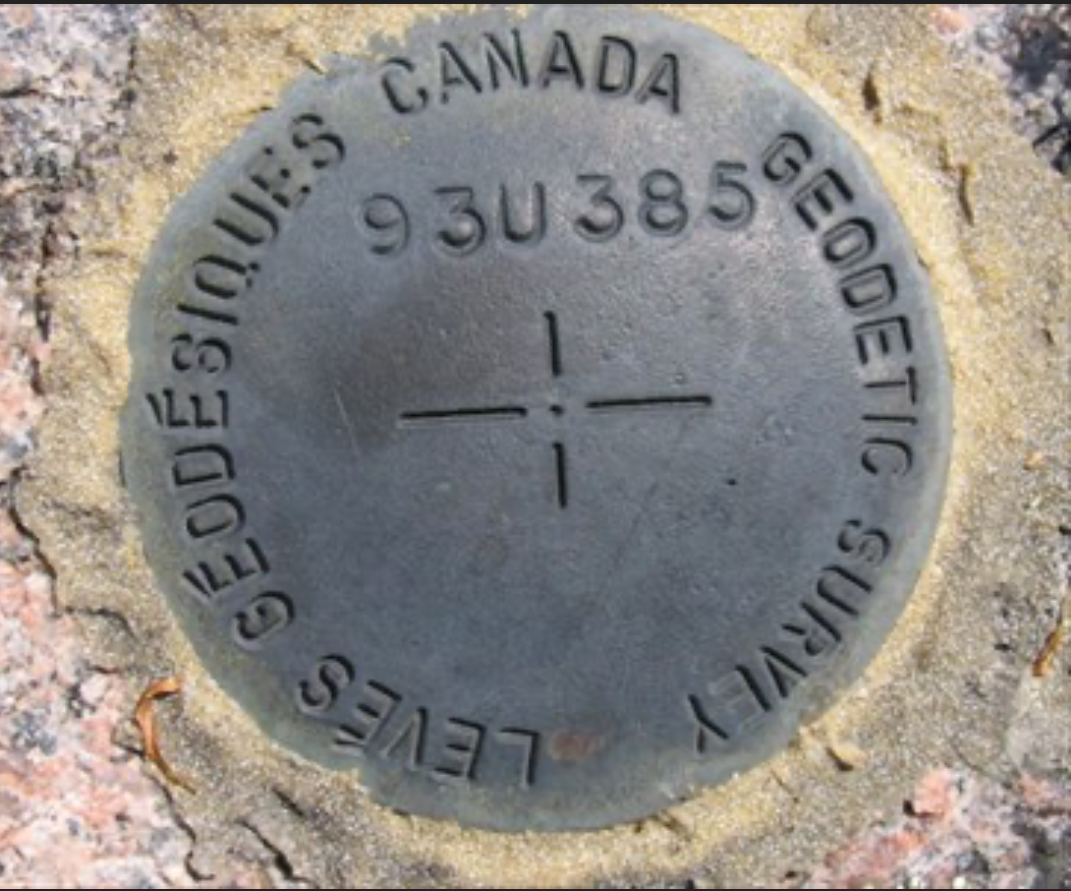
This is a survey monument vs the original post being a control point. Survey monuments are established on a larger scale.
When you need to reference a known elevation or XY coordinate, there is a network of survey monuments with known coordinates, usually installed and documented by governments. You reference a known location’s elevation and north x west coordinates and then use instrumentation to determine angle changes to transfer the known elevation to a series of other locations.
When you section off property or build things, like roads or buildings, you use this network of points and triangulate paths off of them to the job site by calculating angles and distances. Since you have to maintain line of sight while traversing the distance, you add points you can use to pivot on and travel great distances. These points are called ‘control points’ or ‘benchmarks’.
The main post pic is a control point. Your picture is a survey monument.
You see those in the US too. I think the one in original photo is for temporary use. I.e. embed it for your project and leave when done.
That would make sense given the lack of refrence numbers.
Just more proof they’re* holding us down.
*Blessed autocorrect
What was the original text?
< We reach/tether >
< through Control Points >
< into the Bureau/House >
The Rule of Three applies, of course.
Mind control relay. You can try to remove it but are mentally incapable unless you have a tinfoil hat.


![[Solved] Anyone know what this is? They are embedded in the sidewalks around the city](https://programming.dev/pictrs/image/17e2a431-e194-46bc-8e69-34c6419ac8da.jpeg)