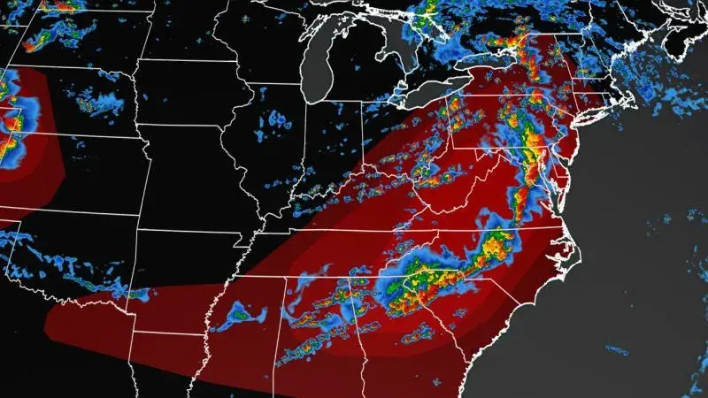
A potent storm system is moving east after battering the Ohio River Valley Sunday and increasing the risk for severe weather Monday across a large area of the country to the east of the Mississippi River.
The worst of it will be from the Appalachians into Maryland, southern Pennsylvania and New Jersey, including Philadelphia, Baltimore and Washington D.C., primarily due to damaging winds. Areas from northeastern Tennessee to parts of Maryland and southern Pennsylvania are under a moderate risk, Level 4 out of 5, for severe storms.
An area from northern Alabama into southern New York, including Atlanta, Charlotte, North Carolina, and Binghamton, New York, is under an enhanced risk, Level 3 out of 5, for severe storms. A slight risk for severe storms, a Level 2 of 5, spreads from western Alabama to southern New York, including New York City, Pittsburgh, Charleston, South Carolina, Virginia Beach, Virginia and Wilmington, North Carolina. Parts of the Northeast could also see heavy rainfall in association with these storms. A slight risk for excessive rainfall, or a Level 2 of 4, has been issued for the Northeast.
Scattered rainfall of 2 to 4 inches is possible Monday. “In the areas of thunderstorms, severe weather and flash flooding will be a threat,” the National Weather Service said.
There were over 150 storm reports across the East on Sunday and over 130 Saturday, including eight tornadoes, spread across Colorado, Illinois, Iowa and Nebraska.
There were another 92 reports of damaging wind and 37 reports of large hail, mainly across the central Plains and mid-Mississippi River Valley.
While parts of the East brace for hail and heavy rain, cities from Arizona to Florida will continue to deal with dangerous heat this week. “Numerous record high temperatures and record high morning minimum temperatures are likely over the next few days with no end in sight going into the later part of this week,” the National Weather Service said.
Excessive heat warnings and heat advisories in effect across the southern part of the country, from southeast California into Florida, will likely remain in effect “for the foreseeable future as there is no relief in sight to the heat for the remainder of the week across these areas,” the weather service said.
About 65 records were set or tied on Saturday and Sunday so far across cities in Arizona, Louisiana, Mississippi, New Mexico and Texas. At least 120 more could be set from Sunday through Tuesday.
Austin, Texas, hit 105 degrees Sunday, marking the 30th consecutive day with a high temperature over 100 degrees.
Albuquerque reached a high of 102 Saturday – breaking the prior record of 98 degrees set in 1995. This is also the hottest August day ever in the city.
In New Orleans – where city officials warned that high humidity levels will result in temperatures that “feel like” 115 degrees or higher – cooling centers were open for residents in need of respite from the heat, officials said.
“The forecasted excessive heat warning for Monday, Aug. 7 will mark the 17th excessive heat warning issued for 2023 so far, beating the previous record of five warnings in 2021,” New Orleans officials said in a news release.


What the hell?