You’ve replied to another comment in the thread indicating that you get it, so nice! But just in case other readers are looking here, I’ll reply to your comment here as though you were someone else.
we have computers that can pretty accurately represent depth
No, computer (monitors/screens) cannot represent depth. Those are still 2d planes, and cannot represent 3d information without distortion. When computers calculate and display depth, they do so through illusion of depth, perspective, and parallax.
This is not a technological problem, it’s physical and mathematical. You cannot consolidate 3d information into 2d information without distorting something.
the old projections we drew on maps.
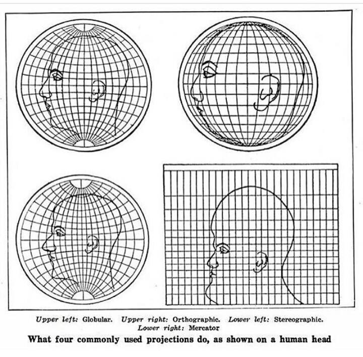
We still use projections on maps, both paper and electronic. Because we must. They are the only way of taking 3d information and rendering it to 2d information. All projections have distortions, and the map makers takes her pick of what she is distorting (usually size and shape, but it could be direction or continuity a la Waterman Butterfly.) There is nothing special about computers compared to doing a projection by hand, other than it’s much faster to do it on a computer.
Stretching it out flat (zooming in on google earth) has less distortion than these projections shown here, don’t they?
“Stretching it out flat” is projection*. It may appear to be less distorted to your human eyes because you’re zooming in continually as you scroll your mouse, so it looks like it all blends in together. But that doesn’t mean it’s actually more accurate or less distorted than a map with a reasonably chosen projection for the area. Because you fundamentally cannot take a 3d object and make it 2d while keeping all the information. (Try it yourself! Try to peel an orange while keeping its peel entirely intact and while making the peel come out in a rectangle. No cutting off bits allowed, we want that peel to come right back to wrapping around the orange after.)
This is a huge oversimplification on my part since im just referring to the “essence” of what we’re trying to achieve by projecting a globe to maps. Projecting isn’t literally stretching a 3D shape until it’s basically 2d, it’s more like uv mapping/texturing in blender. To be clear, I don’t actually know if Google Earth reprojects on-the-fly to accommodate a high-scale view (though I would suspect they do since it would be weird to use a GCS to view a local area.)


You’ve replied to another comment in the thread indicating that you get it, so nice! But just in case other readers are looking here, I’ll reply to your comment here as though you were someone else.
No, computer (monitors/screens) cannot represent depth. Those are still 2d planes, and cannot represent 3d information without distortion. When computers calculate and display depth, they do so through illusion of depth, perspective, and parallax.
This is not a technological problem, it’s physical and mathematical. You cannot consolidate 3d information into 2d information without distorting something.
We still use projections on maps, both paper and electronic. Because we must. They are the only way of taking 3d information and rendering it to 2d information. All projections have distortions, and the map makers takes her pick of what she is distorting (usually size and shape, but it could be direction or continuity a la Waterman Butterfly.) There is nothing special about computers compared to doing a projection by hand, other than it’s much faster to do it on a computer.
“Stretching it out flat” is projection*. It may appear to be less distorted to your human eyes because you’re zooming in continually as you scroll your mouse, so it looks like it all blends in together. But that doesn’t mean it’s actually more accurate or less distorted than a map with a reasonably chosen projection for the area. Because you fundamentally cannot take a 3d object and make it 2d while keeping all the information. (Try it yourself! Try to peel an orange while keeping its peel entirely intact and while making the peel come out in a rectangle. No cutting off bits allowed, we want that peel to come right back to wrapping around the orange after.)